A July joke about swimming
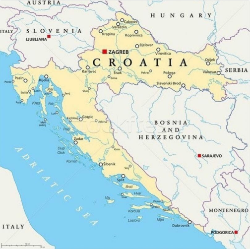
On July 4, 2018, the Twitter user ohNoobDerp posted a map with a short scene: the Bosnians want to go for a swim, and Croatia refuses. The outline of the neighboring countries already provided the visual basis for such an exchange. The tweet spread widely, and then variants appeared in the Reddit communities r/me_irl and r/mapporncirclejerk. Participants began replacing the geographic roles with people, habits, and circumstances that stand in the way of reaching a goal.
The joke is built on a strong simplification. Bosnia and Herzegovina is not completely cut off from the Adriatic: near the town of Neum it has a stretch of its own coastline. This fact also produced amendments to the original line, in which the refusal was softened to permission to swim “a little.” The geographic caveat became part of the game with the map, since a narrow passage is easy to picture as a small concession between two large roles.
A yellow strip along the blue sea
In the image, Croatia is highlighted in yellow and the sea in blue. Bosnia and Herzegovina occupies a light area inside the bend of the Croatian outline. The states, cities, and islands are labeled; Zagreb and Sarajevo are marked with red squares. Neighboring countries are visible at the top, and Serbia and Montenegro on the right. This is a detailed geographic map with no added meme captions or arrows.
Its design lets one see at once the entire barrier and what lies behind it. Croatia's long coastal territory draws attention more strongly than Bosnia's small outlet to the water. That is why the meme reading often begins with the general impression of “almost closed off.” If the map is heavily reduced or cropped, the small passage becomes even harder to notice, but such a perception does not change the real existence of the Neum coastline.
The states take on everyday roles
In the remake, the inner area stands for the one who wants something, the sea for the desired result, and the long surrounding strip for the obstacle. Unlike the usual picture of a closed door, here the barrier looks extended and seems to repeat the outline of the one in need. The goal appears very close, yet there is almost nowhere a convenient direct path. The viewer carries this spatial unfairness over into their own situation.
The map can also be assigned less literal relationships: work surrounds free time, preparation blocks access to rest, and rules stand between a person and a simple service. Then the geography turns into a diagram of desire. The resemblance arises not from the historical relations between the states but from the arrangement of the colored areas. The image explains the clash of roles in a second, keeping the captions short and allowing the original joke's exchange to be repeated in a new everyday plot.
Three fictional maps of obstacles
An invented version: the inner area is “Me,” the coastal strip is “Cable forgotten at home,” and the sea is “Charged phone.” The desired result seems easily reachable, but the needed means is somewhere else. A second scenario assigns Bosnia the role of “Day off,” Croatia the role of “Chores postponed until the weekend,” and the Adriatic the role of “Rest.” The long strip shows how earlier decisions have surrounded a small free day.
A third example: “I want to listen to music” inside, “Five minutes of searching for headphones” along the shore, and “Favorite track” instead of the sea. It turns the obstacle not into an absolute one but into an annoyingly mandatory one. All the examples are fictional and use the map as a conventional diagram. The small outlet near Neum even helps the reading: what is needed is sometimes reachable, but access looks much narrower and less convenient than a person standing before such a map of their own plans would like.